Up:Next: Next: Hike starting from Ohlone Previous Previous Hikes up Mission Peak, Fremont,
![]()
![]()
![]()
Up:Next: Next: Hike starting from
Ohlone Previous Previous Hikes up Mission Peak,
Fremont,
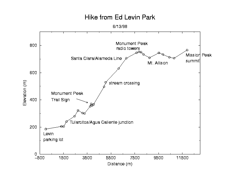
Click on the image for a large postscript version with better fonts (20K).
Photographic trail guide to the ascent.
The round-trip distance from Ed Levin Park to the Mission Peak summit using this route would be 23.8 km, too far for us. Instead we hiked 15.7 km one-way from Levin to Stanford Avenue, taking the Horse Heaven Trail down Mission Peak and bypassing the summit. The duration of this hike was about 6 hours including a lunch break.
The hike begins in Ed Levin Park, climbs up Monument Peak, passes the Mt. Allison summit on a level ridgetop segment, then joins up with the Mission Peak trail system. As with the trip from the Sunol trailhead, this route is longer, less steep and less crowded than the hikes from the Ohlone and Stanford Avenue trailheads. The walk between Monument Peak and Mission Peak is quite flat and goes quickly. This segment is a part of the Bay Area Ridge Trail and there is a description on their website.